Welcome to RTKSurvey.com

GNSS RTK Check Shots: How to Verify Survey Accuracy in the Field
A GNSS RTK receiver showing a FIX solution is encouraging, but it does not automatically mean that every measured coordinate is correct.
Incorrect base coordinates, antenna height mistakes, coordinate transformations and local interference can all affect survey results even when the receiver reports a fixed solution.
This is why professional surveyors perform RTK check shots before and during fieldwork.
A check shot is a measurement used to compare the RTK system's reported coordinates with an independently established reference or another suitable quality-control observation.
Quick Answer: How Do You Check GNSS RTK Accuracy?
The most useful starting point is to measure a known survey control point and compare the RTK coordinates with its accepted reference values.
A practical field verification procedure includes:
Confirm the correct coordinate system and antenna settings.
Obtain a stable RTK FIX solution.
Measure a known control point.
Compare horizontal and vertical coordinate differences.
Repeat the observation after an independent initialization.
Record the results and confirm they meet project tolerances.
A FIX status and a small receiver-reported accuracy estimate are not substitutes for independent field checks.
1. Why GNSS RTK Check Shots Matter
RTK positioning uses satellite observations and correction data to calculate precise coordinates.
Under suitable conditions, modern GNSS RTK systems can provide centimeter-level positioning.
However, the displayed solution status primarily describes the receiver's positioning solution. It does not independently verify the correctness of the reference coordinates or project coordinate system.
For example, a rover may report FIX while using an incorrect base station position.
The resulting coordinates can appear stable but still contain a systematic offset.
A check shot against an independently established control point can reveal this type of problem before it affects an entire survey.
For a detailed discussion, see RTK Fixed but Wrong Coordinates.
2. Start With a Reliable Control Point

A useful check point must have trustworthy reference coordinates.
Ideally, the point should be established through an independent survey method or a properly controlled network, with coordinates appropriate for the project's datum, epoch and vertical reference.
Do not assume that any previously saved coordinate is suitable for checking the current RTK setup.
Before observing the point, verify:
Control point identification and physical stability
Coordinate reference system and projection
Applicable datum and coordinate epoch
Height reference and geoid model, if used
Required horizontal and vertical tolerances
If the check point was established using the same incorrect base coordinates or transformation being tested, the check may fail to reveal the underlying error.
A control check is only as reliable as its reference coordinates.
3. Calculate Horizontal and Vertical Differences
After measuring a known point, compare the RTK coordinates with the accepted reference values.
For projected coordinates:
ΔE = E(measured) − E(reference)
ΔN = N(measured) − N(reference)
The horizontal coordinate difference is:
Horizontal Difference = √(ΔE² + ΔN²)
The vertical difference is:
ΔH = H(measured) − H(reference)
Consider this illustrative example:
| Coordinate | Reference | RTK Measurement | Difference |
|---|---|---|---|
| Easting (m) | 500000.000 | 500000.014 | +0.014 m |
| Northing (m) | 3200000.000 | 3199999.988 | −0.012 m |
| Elevation (m) | 125.430 | 125.451 | +0.021 m |
The horizontal difference is approximately 18 mm, while the vertical difference is 21 mm.
Whether these results are acceptable depends on the project's accuracy requirements.
These numbers are examples, not universal GNSS RTK acceptance limits.

4. Repeat the Check After Independent Initialization
One measurement may not reveal every positioning problem.
A stronger procedure includes a second observation after an independent RTK initialization.
For example, the surveyor may:
Measure the known control point.
Save the observation and record the solution status.
Reinitialize the RTK solution according to the receiver's operating procedure.
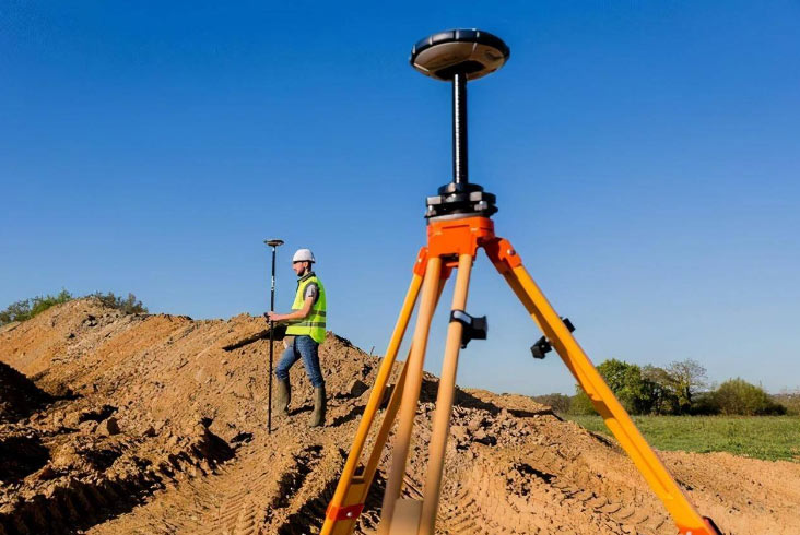
Reoccupy the point with the pole correctly centered.
Measure again and compare both results.
Where project requirements call for stronger independence, observations can also be separated in time to obtain different satellite geometry.
Simply saving several consecutive points from one uninterrupted FIX solution is not equivalent to independent observations.
Repeated measurements help evaluate consistency, but agreement between them does not prove absolute coordinate accuracy.
5. Check Antenna Height and Pole Position
Some RTK errors are caused by simple field setup mistakes.
A wrong antenna height can directly affect the reported elevation.
For example, entering a pole height of 2.000 m when the actual configured measurement height should be 1.800 m can introduce a substantial vertical error, depending on the software's antenna reference settings.
Surveyors should confirm:
Actual pole height
Antenna reference point and measurement method
Pole verticality
Correct antenna model and offsets
Secure mounting of the receiver
A tilted pole can also create horizontal positioning errors, especially when measuring points with a tall pole.
If the equipment uses tilt compensation, verify its operating requirements and calibration status rather than assuming compensation is always active and accurate.
6. When Should You Perform RTK Check Shots?
Check shots should be integrated into the survey workflow, not treated as an optional final step.
Useful checkpoints include:
| Survey Stage | Recommended Verification |
|---|---|
| Before starting | Check known control and coordinate settings |
| After changing the base setup | Verify the new correction configuration |
| After changing localization | Recheck independent control |
| After significant equipment changes | Confirm antenna and receiver settings |
| During extended fieldwork | Perform periodic independent checks |
| Before leaving the site | Complete final checks and review records |
The required frequency depends on the survey specification, project risk and operating conditions.
Some projects require formal checks at defined intervals or after specific events. Always follow the applicable client and surveying authority requirements.
7. What If the RTK Check Shot Fails?
Suppose the project allows a maximum horizontal check difference of 30 mm, but the observed difference is 85 mm.
Do not immediately average the result or assume the control point is wrong.
Instead, investigate systematically.
First, check the setup. Confirm the point identification, pole height, centering and antenna settings.
Second, review the coordinate system. Check projection, datum, localization and height conversion settings.
Third, verify corrections. Confirm the intended base station or NTRIP mountpoint is being used.
Fourth, repeat the observation independently. If possible, check a second reliable control point.
Finally, assess previous measurements. If a systematic error is confirmed, determine which observations may have been affected before continuing production work.
If the receiver cannot maintain a reliable FIX solution, see our troubleshooting guide RTK Not Getting Fixed.
Field Example: Road Construction Stakeout
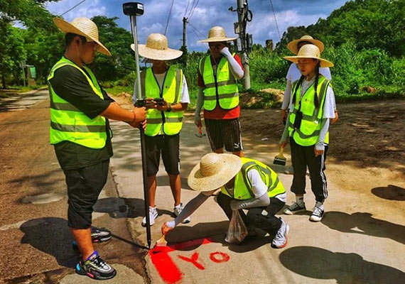
Consider a survey crew setting out points for a road construction project.
The team uses a GNSS RTK rover connected to a network correction service.
At the start of the day, the surveyor measures two established project control points and confirms that the differences meet the project's specified tolerances.
The crew then begins staking out design points.
After changing the rover's antenna height setting and moving to another work area, the surveyor performs another control check.
The new observation shows an unexpected vertical difference.
Further inspection reveals that the antenna height entry was not updated correctly.
The crew corrects the setting, rechecks the control point and reviews observations made after the change.
This hypothetical example illustrates how routine check shots can identify errors before they spread through a project.
GNSS RTK Field Quality Control Checklist
| Check Item | What to Record |
|---|---|
| Control point | Point ID and reference coordinates |
| RTK solution | FIX status and observation time |
| Correction source | Base station or NTRIP service |
| Antenna setup | Model, height and measurement method |
| Coordinate system | Datum, projection and height reference |
| Horizontal check | Easting, northing and horizontal differences |
| Vertical check | Elevation difference |
| Independent repeat | Second observation and comparison |
| Acceptance | Project tolerance and pass/fail decision |
Keep the original observation records where practical. A simple pass/fail statement without the underlying measurements may be insufficient for later quality review.
Frequently Asked Questions
Does RTK FIX mean centimeter accuracy is guaranteed?
No. A FIX solution does not independently verify coordinate reference settings, antenna height or the accuracy of the control network.
How many check shots are required?
There is no single number suitable for every project. Requirements depend on the survey specification, control quality, site conditions and intended deliverables.
Can I use the same point for every RTK accuracy check?
A stable known point can be useful for routine checks, but checking additional independent points helps detect errors that a single-point comparison may miss, including certain transformation and localization problems.
Is repeating the same RTK point enough?
Not necessarily. Repeated observations help evaluate precision, but independently established control is needed to assess agreement with the project's coordinate reference.
Final Thoughts
GNSS RTK check shots are a practical way to improve survey quality and identify coordinate problems early.
A reliable procedure combines known control points, independent observations, correct equipment settings and documented acceptance criteria.
The goal is not simply to obtain a FIX solution. It is to demonstrate that the measured coordinates are suitable for the intended survey.
RTKSurvey.com supplies professional GNSS Receivers and Survey Data Collectors from multiple brands for international surveying customers.