Welcome to RTKSurvey.com

What Is CORS in GNSS Surveying? How CORS RTK Works
A surveyor purchases a GNSS RTK rover and plans to use a regional CORS service instead of operating a local base station.
The rover tracks satellites, the field controller connects to mobile internet, and the operator enters the correction service's NTRIP credentials.
But the receiver remains in Float.
On another project, a rover connects successfully and obtains RTK Fixed, yet its coordinates do not agree with the construction site's established control points.
These situations demonstrate why understanding CORS involves more than knowing the caster address and password.
A CORS network can provide an efficient reference infrastructure for GNSS surveying, but reliable results still depend on correction compatibility, service coverage, reference frames and proper field verification.
What Is CORS in GNSS Surveying?
CORS stands for Continuously Operating Reference Stations.
A CORS is a permanently installed GNSS reference station that continuously collects satellite observations at a stable, well-defined location.
A CORS network consists of multiple such stations and the supporting communication, processing and data-distribution infrastructure.
Depending on the service, CORS observations may be used for real-time GNSS corrections, post-processing, reference-frame maintenance or other positioning applications.
For RTK surveying, the main benefit is that surveyors may be able to obtain correction data without setting up their own base station at every project.
However, not every CORS network provides a real-time RTK service, and not every real-time service offers the same coverage, correction formats or coordinate reference.
Before relying on a network, the surveyor must understand what service is actually available.
How Does a CORS GNSS Network Work?
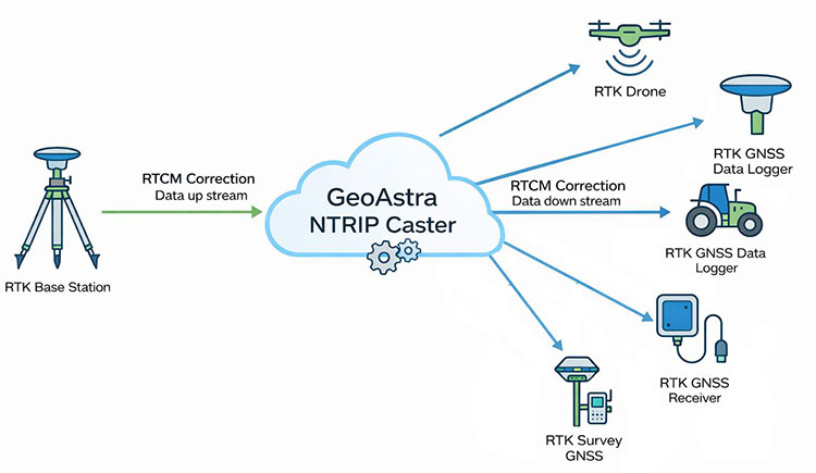
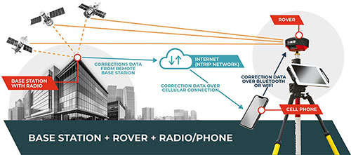
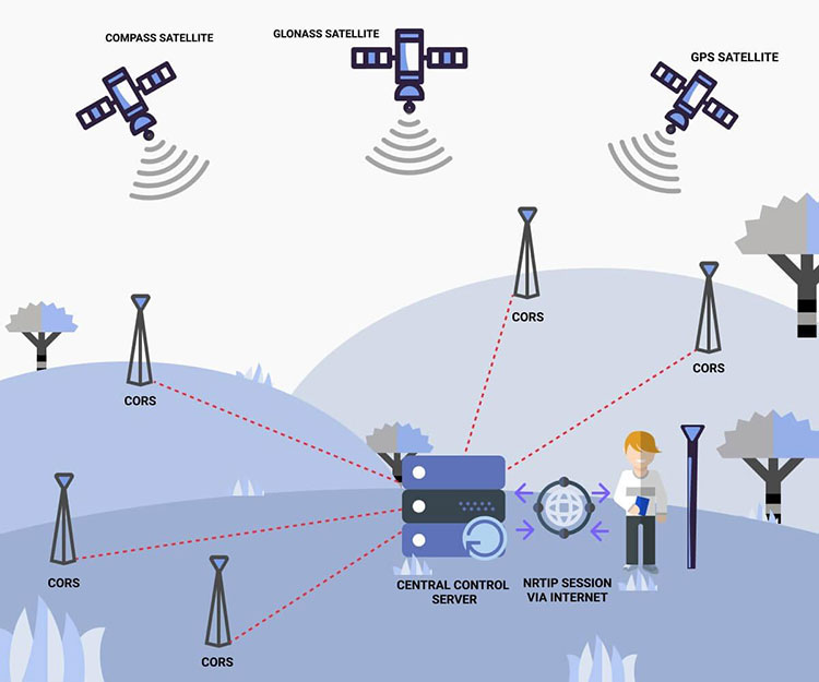
A permanent reference station tracks GNSS satellites from a known reference location.
Its observations are transferred to processing and distribution infrastructure.
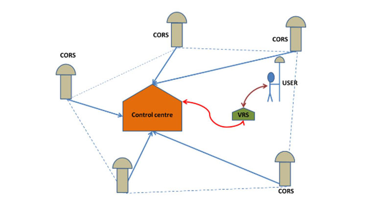
Depending on the network architecture, the system may provide data from an individual reference station or generate corrections using information from multiple stations.
A rover receives the relevant corrections and combines them with its own satellite observations to calculate a high-precision position.
The Main Components
A typical real-time CORS service includes several elements.
Reference stations: Permanently installed GNSS receivers with suitable antennas, stable monuments, reliable power and communication connections.
Processing infrastructure: Systems that collect reference observations, monitor station performance and, where applicable, generate network correction products.
Correction distribution: Servers or casters that make supported data streams available to users.
GNSS rover: The field receiver that collects its own satellite observations and applies suitable correction information.
Communication link: Usually an internet connection between the rover and the correction service.
The details vary between providers. A public national network, a regional subscription service and a privately operated reference network may have different capabilities.
CORS, NTRIP and Network RTK: What Is the Difference?
These terms are often used together, but they describe different things.
| Term | Meaning | Main function |
|---|---|---|
| CORS | Continuously operating GNSS reference station infrastructure | Supplies reference observations and positioning infrastructure |
| NTRIP | Protocol for streaming GNSS data over IP networks | Delivers correction data to compatible users |
| Single-base RTK | Relative RTK positioning using one reference station | Computes rover position relative to a reference |
| Network RTK | RTK service using observations and modeling from multiple reference stations | Supports positioning across a reference-station network |
| RTCM | Standardized GNSS data and correction message formats | Helps exchange correction information between systems |
A rover may receive single-station corrections from a CORS through NTRIP.
It may also receive network RTK corrections generated from multiple CORS stations.
Therefore, connecting to CORS does not automatically mean that the rover is using a network RTK solution.
The selected service and mountpoint determine what type of correction information is being delivered.
Single-Station CORS vs Network RTK
A CORS service may offer more than one correction method.
Understanding the difference is important when selecting a mountpoint or evaluating performance.
Single-Station RTK
In a single-reference-station arrangement, the rover uses correction data associated with one reference station.
The rover's distance from that station affects how closely some GNSS observation errors are shared.
As the baseline becomes longer, atmospheric differences and other effects can make ambiguity resolution more difficult.
This does not mean every long baseline will fail. Actual performance depends on the equipment, correction processing, observations and prevailing conditions.
Network RTK
Network RTK uses observations from multiple reference stations to support positioning across a service area.
Different networks may use different processing methods and correction products.
Three commonly encountered approaches are VRS, MAC and FKP.
VRS: Virtual Reference Station
A Virtual Reference Station service generates correction information associated with a virtual reference location near the rover.
The network uses observations from multiple physical stations and its processing models to produce the relevant data.
VRS services commonly need an approximate rover position to determine the appropriate virtual reference location.
That is one reason a network service may require an NMEA GGA message from the rover.
The exact implementation and supported correction messages depend on the provider.
MAC: Master-Auxiliary Concept
MAC is a network RTK approach that provides information associated with a master station and auxiliary stations.
A compatible rover can use this information in its positioning calculations.
Support for the required network messages and processing method must be confirmed.
FKP: Area Correction Parameters
FKP uses area correction parameters derived from network observations.
These parameters describe modeled spatial variations that can support positioning across the network area.
As with other network RTK approaches, practical compatibility and performance depend on the service implementation and rover capabilities.
Which Network Method Is Best?
There is no universal answer.
A surveyor normally should not select VRS, MAC or FKP based only on the terminology.
Instead, confirm which streams the CORS provider supports, which formats the rover can process and which service the provider recommends for the intended location.
How to Connect an RTK Rover to a CORS Service
The exact menus differ between GNSS brands and field controllers, but the underlying connection procedure is similar.
Step 1: Confirm the CORS Service Covers the Project
Before entering settings, verify that the service supports real-time corrections in the survey area.
Check the provider's published coverage, access conditions, supported correction methods and any restrictions.
Do not assume that a station appearing on a map guarantees the required accuracy or real-time service at every nearby location.
Step 2: Obtain the NTRIP Connection Information
A typical service may provide:
| Setting | What it identifies |
|---|---|
| Caster address | Hostname or IP address of the NTRIP service |
| Port | Network port used by the caster |
| Username | User account identification |
| Password | Account authentication |
| Mountpoint | Selected correction stream |
| Correction format | Supported RTCM or other service format |
| GGA requirement | Whether the rover must send its approximate position |
These values must come from the actual CORS provider.
Using settings from another network may result in failed authentication, incompatible corrections or an unsuitable reference stream.
Step 3: Establish Internet Connectivity
Connect the rover or controller through its supported mobile-data or internet interface.
Confirm that the device can reach the correction service.
A cellular signal indicator alone does not prove that the required internet connection is working.
Step 4: Configure the NTRIP Client
Enter the caster address, port, credentials and mountpoint in the field software.
Select the required connection and correction settings.
If the service requires GGA, confirm that the rover sends an appropriate approximate position.
For VRS and some other location-dependent services, this step may be essential to receiving the intended correction stream.
Step 5: Confirm Corrections Are Being Received
Check the correction status in the field software.
Look for indications that the rover is receiving and processing the expected messages.
Review correction age and any connection errors.
An established internet connection is not sufficient if no usable correction messages are arriving.
Step 6: Obtain and Evaluate the Positioning Solution
Under suitable conditions, the rover may progress to RTK Float and then Fixed.
The sequence and time required vary by receiver, observations and correction service.
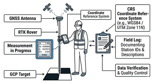
A Fixed indication is useful, but it does not prove that the coordinates match the project's required reference system.
Step 7: Verify Against Independent Control
Occupy suitable known control points and compare the measured coordinates with their accepted values.
Check horizontal and vertical differences against the project's specified tolerances.
If the results do not agree, investigate the reference frame, coordinate transformation, antenna height, geoid model and other settings before beginning production measurements.
Field Case 1: A City Survey Crew Using Regional CORS
Illustrative scenario; not an actual customer project.
A survey company works at several construction sites across a metropolitan area.
The region has an established CORS service, suitable mobile coverage and published connection instructions.
Previously, the crew used a local base station for every assignment.
The New Workflow
The company configures its GNSS rover for the regional NTRIP service.
At each site, the crew connects to the appropriate mountpoint, confirms correction reception and verifies its position against known control.
This removes the need to install and secure a local base for every short assignment.
The Hidden Requirement
The service operates in a specified reference frame, while the construction project uses a local engineering grid.
The crew must apply the approved transformation between the reference positions and project coordinates.
Without that step, the rover could obtain RTK Fixed but display coordinates inconsistent with the construction drawings.
Lesson
CORS can improve field efficiency, but successful connection and successful project-coordinate verification are separate tasks.
Field Case 2: A Cross-Brand Rover Connects but Remains Float
Illustrative scenario; not an actual customer project.
A surveying dealer supplies a GNSS rover to a customer who plans to use a regional CORS service.
The receiver supports NTRIP, and the controller successfully logs in to the caster.
However, the rover does not obtain Fixed.
The Initial Assumption
The customer suspects that the receiver is incompatible with the entire CORS network.
That conclusion is premature.
NTRIP connectivity confirms only that a communication path has been established.
The Investigation
The technician checks the selected mountpoint and discovers that the service offers several streams with different correction configurations.
The team reviews the correction format and required messages against the rover's documented capabilities.
It also checks whether the service requires GGA and whether the rover is sending it correctly.
After selecting an appropriate supported stream and confirming suitable observation conditions, the rover can be tested again.
If the receiver still remains Float, the investigation should continue with satellite tracking, correction age, baseline conditions and other positioning factors.
Lesson
NTRIP support does not guarantee compatibility with every CORS mountpoint.
Before purchasing or supplying a GNSS rover, confirm the actual service configuration rather than relying on the general statement that the receiver “supports CORS.”
Field Case 3: CORS Fixed but Construction Coordinates Are Wrong
Illustrative scenario with hypothetical measurements; not an actual customer project.
A contractor connects to a CORS service and obtains RTK Fixed in an open construction area.
The controller reports an estimated horizontal precision of 0.015 m.
However, a check against established project control shows the following differences:
| Control point | Easting difference | Northing difference |
|---|---|---|
| CP-01 | +0.312 m | -0.084 m |
| CP-02 | +0.318 m | -0.079 m |
| CP-03 | +0.309 m | -0.087 m |
The differences are similar across the three points.
What the Pattern Suggests
The rover's repeated positions may be consistent, but the coordinates are systematically displaced from project control.
This suggests investigating the relationship between the CORS reference frame and the project coordinate system.
It does not, by itself, prove which setting is wrong.
What the Crew Should Check
The team verifies the CORS provider's reference frame and any relevant coordinate epoch.
It then checks the project coordinate system, transformation parameters, control-point definitions and units.
If vertical differences are also present, the geoid and vertical datum require examination.
The crew should not simply apply an arbitrary shift to make one point agree.
After correcting the identified configuration problem, the result should be checked against independent control.
Lesson
A reliable RTK Fixed solution can coexist with incorrect project coordinates.
For a more detailed diagnosis, see RTK Fixed but Wrong Coordinates.
CORS vs Local GNSS Base Station: Which Should You Use?
CORS and a local base station are not mutually exclusive technologies.
A CORS is itself a reference station, but the operational distinction is often between using an existing reference service and operating a dedicated base for a particular project.
| Project condition | Existing CORS service | Dedicated local base |
|---|---|---|
| Suitable real-time service already available | Often convenient | May be unnecessary |
| No suitable correction service coverage | May not be practical | Often worth considering |
| Unreliable mobile internet | Internet delivery may be difficult | UHF delivery may be suitable |
| Short assignments across many sites | Can reduce repeated setup | Requires additional field setup |
| Project-specific reference requirements | Requires reference-frame verification | Can be established directly within the project workflow |
| Multiple rovers | Depends on service access and terms | Can distribute corrections to multiple compatible rovers |
A local base can also distribute its corrections through NTRIP.
The most useful question is therefore not simply “CORS or base station?”
It is: Which reference source and correction delivery arrangement best meets the project's accuracy, coverage and operational requirements?
Our RTK Radio vs NTRIP guide compares the communication methods in more detail.
How Accurate Is CORS RTK?
CORS-based RTK can support centimeter-level positioning under suitable conditions, but there is no universal accuracy figure that applies to every network, receiver and project.
Performance depends on several factors.
Reference Network Quality
The stability, coordinates, equipment and monitoring of the reference stations affect the quality of the service.
Network Geometry and Coverage
Station spacing, rover location and the correction method can influence positioning performance.
A rover operating outside a provider's recommended coverage area may experience reduced reliability.
Satellite Observations
Multipath, obstructions, interference and poor observation geometry can affect positioning even when corrections are being received normally.
Reference Frame and Coordinate Transformation
The network's reference frame must be related correctly to the project's coordinate requirements.
An apparently precise result can still be displaced from local control if this relationship is incorrect.
Field Verification
Receiver precision indicators are useful but do not replace independent checks.
For professional surveying, the final acceptance criteria should come from the project's requirements and applicable standards.
Common CORS Connection Problems and Their Causes
| Symptom | First checks |
|---|---|
| Cannot connect to caster | Internet, server address, port, account status |
| Authentication rejected | Username, password, subscription or permissions |
| Connected but no corrections | Mountpoint, service status, GGA requirement |
| Corrections received but no Fixed | Message compatibility, satellite observations, correction quality |
| Fixed but wrong project coordinates | Reference frame, transformation, antenna height, vertical settings |
| Works in one area but not another | Service coverage, internet coverage, observation environment |
These checks help narrow the problem, but they are not a substitute for the correction provider's documentation or a systematic field diagnosis.
If the receiver changes between Single, Float and Fixed, our guide to RTK positioning status and accuracy explains what those states mean.
What Should Buyers Check Before Choosing a CORS-Compatible GNSS Receiver?
For surveying contractors and equipment dealers, compatibility should be evaluated against the intended correction service.
NTRIP Client Support
Confirm that the receiver or its field software supports the connection method required by the service.
Correction Message Compatibility
Check the supported RTCM messages and the actual correction formats offered by the provider.
A general NTRIP capability statement is not enough to establish compatibility with every mountpoint.
Network RTK Support
If the intended service uses VRS, MAC, FKP or another network processing method, verify the receiver and software requirements.
GGA Messaging
Determine whether the correction service requires the rover to send an approximate position.
Internet Connectivity
Consider whether the receiver uses an internal modem, controller-based mobile data or another supported connection arrangement.
Coordinate-System Management
For construction and engineering work, the field software should support the coordinate systems and transformations required by the project.
Local Operating Conditions
A receiver that connects successfully to CORS may still struggle in areas with poor sky visibility or interference.
Equipment evaluation should include the environments where the customer actually works.
RTKSurvey.com supplies GNSS RTK receivers for surveying and construction applications.
When evaluating a receiver for a particular CORS network, the most useful information includes the provider's correction format, mountpoint requirements, reference frame and intended working area.
Frequently Asked Questions
What Does CORS Stand for in GNSS?
CORS stands for Continuously Operating Reference Stations. These are permanently installed GNSS reference stations that collect observations continuously and support positioning services and other geodetic applications.
Can I Use CORS Without My Own Base Station?
Yes, if a suitable CORS correction service is available and your rover can access and process its corrections. You still need to verify the resulting coordinates against the project's requirements.
Is CORS the Same as NTRIP?
No. CORS refers to reference-station infrastructure, while NTRIP is a protocol used to distribute GNSS correction data over IP networks.
Is CORS Always Network RTK?
No. A CORS service may provide corrections from an individual reference station or offer network RTK products derived from multiple stations.
Do All GNSS RTK Receivers Support CORS?
Not necessarily. Compatibility depends on the receiver, field software, communication functions, correction messages and requirements of the particular service.
Why Does My CORS Rover Stay in Float?
Possible causes include unsuitable correction messages, missing GGA information, correction delays, poor satellite observations or other ambiguity-resolution problems. The correct diagnosis depends on what the receiver is actually receiving and observing.
Can CORS RTK Work Without Internet?
A typical rover receiving real-time CORS corrections through NTRIP requires an internet connection. Other data-delivery arrangements may exist, but offline GNSS observations do not by themselves provide live NTRIP corrections.
Does CORS Guarantee Centimeter Accuracy?
No. CORS can support high-precision positioning, but the final result depends on the service, rover observations, reference configuration and independent verification.
Final Thoughts
CORS networks make high-precision GNSS surveying more accessible by providing permanent reference infrastructure and, where available, real-time correction services.
But connecting a rover to CORS is only the beginning of a reliable workflow.
The surveyor must understand the correction service, confirm equipment compatibility, use the correct reference framework and verify measurements against independent control.
For equipment buyers, the most important question is not simply whether a GNSS receiver advertises CORS support.
It is whether the complete receiver, communication and field-software setup can work reliably with the specific correction service and survey requirements of the project.