Welcome to RTKSurvey.com

RTK Radio vs NTRIP: Which Correction Method Should You Use?
A GNSS survey crew is working on a highway project outside mobile network coverage. The rover tracks satellites normally, but its NTRIP connection repeatedly drops. On another project, a surveyor moves between several urban construction sites and spends valuable time setting up a local base station at each location.
Both crews need reliable RTK corrections, but the most practical way to deliver those corrections is different.
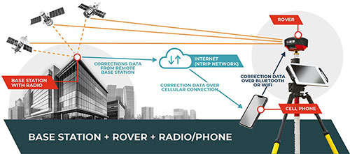
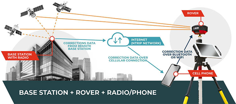
UHF radio and NTRIP are methods of transmitting GNSS correction data, not competing RTK accuracy algorithms. UHF typically delivers corrections directly from a local base station over a radio link. NTRIP delivers corrections over an internet connection, using data from a single reference station, a privately operated base or a GNSS reference network.
The right choice depends on the site, not simply on which method is newer or which receiver advertises the longest communication range.
RTK Radio vs NTRIP: Key Differences
| Factor | UHF Radio RTK | NTRIP RTK |
|---|---|---|
| Correction delivery | Direct radio link | Internet-based data stream |
| Rover internet connection | Not required | Required through a suitable connection |
| Local base station | Normally used | Optional when a suitable external service is available |
| Main coverage constraint | Terrain, radio propagation and interference | Internet availability and correction-service coverage |
| Typical equipment | GNSS base, radio transmitter, rover and antennas | GNSS rover, internet connection and correction source |
| Common interruption | Radio signal blocked or too weak | Internet, caster or service connection lost |
| Operational cost | Base equipment, power, setup and maintenance | Data service and possibly correction subscription |
| Accuracy | Depends on reference and observation quality | Depends on reference and observation quality |
A UHF system may be more dependable where mobile coverage is poor. NTRIP may be more efficient where an appropriate correction service and internet connection are available.
Neither conclusion applies to every site.
How UHF Radio RTK Works
In a typical local base-and-rover setup, the base station occupies a fixed position and collects GNSS satellite observations.
It broadcasts correction messages through a compatible radio transmitter. The rover receives those messages and combines them with its own satellite observations to calculate an RTK position.
The correction path does not require the rover to connect to the internet.
This makes UHF attractive for construction projects, agricultural surveys, rural mapping and other operations where cellular coverage is unreliable.
A Local Base Still Needs Correct Coordinates
Radio communication only delivers the correction data. It does not establish the accuracy of the base station's reference position.
If the base is initialized with inaccurate coordinates, the rover may produce precise relative measurements that do not match the project's established control.
For construction layout, the base coordinates, coordinate reference system and antenna setup must be verified before production measurements.
Why Advertised Radio Range Is Not Guaranteed
Radio range depends on more than transmitter power.
Antenna height, terrain, frequency, modulation, interference, cable losses and receiver sensitivity all affect coverage.
Consider two sites using the same radio equipment.
At the first site, the base antenna is elevated on open ground with a relatively clear path to the rover. Communication may remain reliable over a considerable distance.
At the second site, the rover moves behind a ridge. Even at a shorter distance, the correction signal may become unusable.
This is why a manufacturer's maximum radio-range figure should not be treated as a guaranteed operating radius.
Transmitter power and frequency selection must also comply with local regulations.
How NTRIP RTK Works
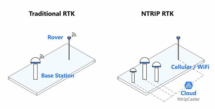
NTRIP stands for Networked Transport of RTCM via Internet Protocol.
It is a protocol used to stream GNSS correction information over IP networks.
A rover normally connects to an NTRIP caster using a compatible receiver, controller or communication device.
The user selects a correction stream, commonly called a mountpoint. The rover receives the correction messages and uses them in its RTK calculation.
NTRIP Does Not Always Mean CORS
A common misunderstanding is that NTRIP always means connecting to a public CORS network.
It does not.
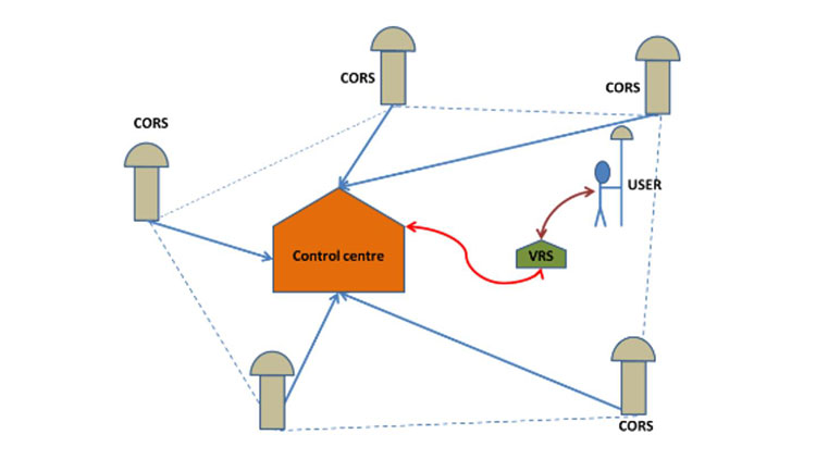
NTRIP can distribute corrections from a privately operated GNSS base station, an individual permanent reference station or a network RTK service.
A company can operate its own local base and send the correction stream to an NTRIP caster. Compatible rovers can receive that stream wherever suitable internet connectivity and service access are available.
For a detailed explanation of permanent reference stations, see our guide to CORS in GNSS surveying.
What NTRIP Depends On
An NTRIP rover needs more than an active mobile-data connection.
It also needs access to a suitable correction source, compatible correction messages and the correct connection configuration.
A controller may show that it is connected to the internet while the NTRIP caster is rejecting its credentials.
Alternatively, the rover may connect to a caster but receive a correction stream that is unsuitable for its location or equipment configuration.
These are different problems and require different checks.
Field Case 1: A Remote Highway Project Without Reliable Internet

Illustrative field scenario; not an actual customer project.
A contractor is surveying a new road through hilly terrain.
The crew needs RTK positioning for earthwork measurements, drainage layout and construction control.
Mobile coverage is available near the site entrance but disappears along several sections of the route.
Why NTRIP Becomes Difficult
The rover connects to a regional correction service near the entrance and obtains RTK Fixed.
Farther along the road, the mobile-data connection becomes intermittent.
Correction age increases, the rover loses its reliable RTK solution and the crew must interrupt precision measurements.
The underlying problem is not necessarily the satellite observations. It may be the correction delivery path.
Why UHF May Be Better
The crew installs a local GNSS base station on an appropriately established reference point and broadcasts corrections by UHF.
The rover can now receive corrections without depending on cellular internet.
However, the crew discovers that a ridge blocks the radio signal on the far side of the project.
The team must evaluate a different base location, improved antenna placement or another communication arrangement.
Field decision: UHF is the stronger primary option where mobile internet is unreliable, provided that radio coverage and the base reference can be established properly.
Field Case 2: Multiple Urban Sites with Good Correction Coverage
Illustrative field scenario; not an actual customer project.
A surveying company completes short assignments across several urban construction sites.
Each site requires a limited number of control checks, topographic observations or layout points.
The area has dependable mobile data and access to a suitable GNSS correction service.
The Local UHF Approach
At each site, the crew transports and sets up a base station, establishes its reference position, configures the radio and secures the equipment.
This may be necessary for projects requiring a dedicated reference setup, but it introduces repeated setup work.
The NTRIP Approach
The rover connects to the existing correction service.
The crew confirms the required coordinate reference and checks known control before beginning measurements.
Provided the service is suitable for the project, the crew can move between sites without repeatedly establishing a local base.
Field decision: NTRIP is often more efficient for short assignments spread across a well-served area. The operational advantage comes from suitable existing infrastructure, not from inherently better RTK accuracy.
Field Case 3: A Quarry Where Terrain Blocks Radio Signals
Illustrative field scenario; not an actual customer project.
A quarry uses a GNSS base station near its site office.
The rover measures stockpiles, access roads and locations inside a deep excavation.
The UHF correction link works well on exposed ground but becomes unreliable behind steep rock faces.
Why More Radio Power May Not Solve the Problem
The rover is operating in a radio shadow.
Increasing transmitter power does not guarantee reliable communication through terrain.
Antenna placement and the geometry of the communication path may be more important than nominal transmitter output.
Could Private NTRIP Help?
Suppose the quarry has a reliable site-wide wireless data network reaching the working areas.
The operator could evaluate distributing corrections from the same local base through an NTRIP caster.
This changes the correction delivery method without necessarily changing the reference station.
However, internet connectivity does not solve poor GNSS satellite visibility at the bottom of the pit.
Field decision: Compare the actual radio and data-network coverage. Where neither provides dependable operation, consider alternative measurement methods or revised field procedures.
Does UHF or NTRIP Provide Better Accuracy?
Neither transport method is automatically more accurate.
If the same rover receives equivalent, timely correction information from the same reference source, switching from radio to internet delivery does not create a fundamentally different positioning algorithm.
In real projects, however, UHF and NTRIP setups often use different reference sources. That can affect the resulting coordinates.
Reference Coordinates
A local base may be tied directly to project control.
A correction network may operate in a specified regional or global reference frame.
The surveyor must ensure that the final coordinates are correctly related to the project's required system.
Baseline Length
With single-base RTK, increasing the separation between base and rover can make it more difficult to model atmospheric differences and resolve ambiguities.
Network RTK services may use additional reference-station information and modeling, but they still have coverage and performance limits.
Correction Age
Delayed or interrupted corrections can reduce the reliability of the solution.
The receiver's correction-age indicator is useful, but it should be interpreted alongside the solution status, observation conditions and equipment documentation.
Independent Verification
A receiver showing RTK Fixed may still produce incorrect project coordinates because of reference errors, antenna-height mistakes or an incorrect fixed solution.
Our guide to RTK Fixed but Wrong Coordinates explains how to diagnose these situations using independent control checks.
Troubleshooting UHF Radio Correction Problems
When UHF corrections stop arriving, begin with the communication path.
Check whether the base is transmitting and whether the rover is receiving correction messages.
Confirm that the equipment uses compatible radio settings and correction formats.
Inspect the base antenna, connectors, cables and power supply.
If the problem occurs only behind terrain or structures, investigate antenna placement and radio coverage before changing unrelated GNSS settings.
A working radio link does not guarantee RTK Fixed. The rover still needs suitable satellite observations.
Troubleshooting NTRIP Correction Problems
For NTRIP, separate internet connectivity from correction-service connectivity.
First confirm that the rover or controller has a functioning data connection.
Then check the caster address, port, credentials and mountpoint.
Verify that the selected correction stream covers the survey area and that the receiver supports its message format.
Some network services require the rover to transmit an approximate position using an NMEA GGA message.
If corrections are arriving but the receiver remains Float, investigate satellite visibility, signal quality, correction suitability and other positioning conditions.
For an explanation of these solution states, read RTK Fixed vs Float vs Single.
Choosing GNSS RTK Equipment for Each Workflow
Correction compatibility should be checked before purchasing a GNSS RTK system.
For UHF Base-and-Rover Work
Confirm that the equipment supports the intended base and rover roles.
Check radio frequency options, correction protocols, supported RTCM messages, antenna arrangements and whether an internal or external transmitter is needed.
Also consider base power requirements and how the station will be secured during operation.
For NTRIP Work
Check whether the receiver and field software support the intended correction service.
Verify NTRIP client functionality, internet connectivity options, RTCM compatibility and any required GGA messaging.
Do not assume that every receiver can connect to every correction service without configuration.
For Mixed Projects
A contractor may use NTRIP in urban areas and UHF on remote sites.
In that situation, equipment supporting both communication workflows may offer operational flexibility.
RTKSurvey.com supplies GNSS RTK receivers for surveying and construction applications.
For the basic reference-station workflow, see our GNSS RTK Base and Rover Setup Guide.
Frequently Asked Questions
Can RTK Work Without Internet?
Yes. A compatible local base-and-rover system can transmit corrections over UHF radio without internet access at the rover.
Is NTRIP More Accurate Than UHF?
Not inherently. Both are correction delivery methods. Accuracy depends on the correction source, GNSS observations, reference configuration and field verification.
Does NTRIP Require a CORS Network?
No. NTRIP can transmit corrections from a privately operated base station as well as from a permanent reference station or network RTK service.
How Far Can UHF RTK Radio Reach?
There is no universal working distance. Coverage depends on equipment, antenna installation, terrain, interference and applicable regulations.
Why Does My Rover Lose Fixed Even When Corrections Are Arriving?
A correction connection does not guarantee successful ambiguity resolution. Satellite obstructions, multipath, cycle slips and other observation problems can prevent a reliable Fixed solution.
Can One GNSS Receiver Use Both Radio and NTRIP?
Many professional receivers support both workflows, but the actual functions depend on the receiver, radio hardware, firmware and field software.
Final Thoughts
The best RTK correction method is the one that can deliver suitable data reliably in the actual working environment.
UHF can be valuable where mobile internet is unavailable, but radio coverage and local base setup must be planned carefully.
NTRIP can simplify work where internet connectivity and appropriate correction services are available, but it introduces dependencies on network access and service configuration.
For many survey companies, the practical solution is not choosing one method permanently. It is selecting equipment and procedures that support the correction workflow required by each project.