Welcome to RTKSurvey.com

RTK Fixed vs Float vs Single: GNSS Accuracy and Field Examples

A GNSS rover shows RTK Fixed in an open construction site. The surveyor walks toward a partially completed building, and the status changes to Float. Under nearby trees, the receiver loses its RTK solution and displays Single.
A few minutes later, the surveyor returns to open ground and obtains Fixed again.
What actually changed? Did the receiver become less accurate? Can the coordinates collected during Float still be used? And does returning to Fixed guarantee that the position is correct?
Understanding these positioning states is essential for reliable GNSS surveying. However, the status indicator is only one part of the accuracy assessment.
This guide explains how RTK Fixed, Float and Single solutions work, what their accuracy differences mean, and how surveyors should respond when positioning status changes during fieldwork.
What Do RTK Fixed, Float and Single Mean?
GNSS receivers calculate positions using signals transmitted by navigation satellites.
The positioning method, available correction information and quality of the observations determine what type of solution the receiver can produce.
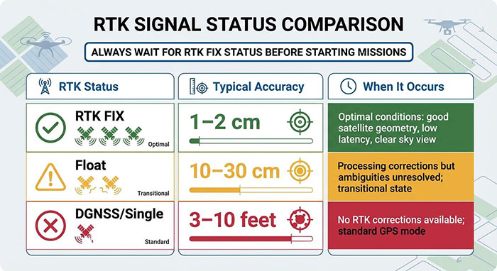
The three commonly displayed states are:
| Positioning status | What it means | Practical interpretation |
|---|---|---|
| Single / Autonomous | Position calculated without an RTK carrier-phase solution | Suitable for general positioning, not normally sufficient for centimeter-level survey control |
| RTK Float | Carrier-phase ambiguities have not been fixed to reliable integer values | A differential carrier-phase solution is available, but its precision and reliability may be insufficient for demanding work |
| RTK Fixed | Integer carrier-phase ambiguities have been resolved | High-precision relative positioning is possible, subject to observation quality and correct reference configuration |
These are solution categories, not universal accuracy guarantees.
A receiver displaying Fixed can still produce incorrect project coordinates if the base station position, coordinate system or antenna height is wrong.
Similarly, a Float solution does not always have the same error magnitude. Its performance depends on the satellite geometry, signal quality, baseline, corrections and processing conditions.
1. Single Solution: Positioning Without an RTK Fix
A Single solution, sometimes labeled Autonomous or Standalone, is calculated without a valid RTK carrier-phase solution.
The receiver estimates its position using satellite observations and navigation information, but it does not have the successfully resolved differential carrier-phase ambiguities required for RTK Fixed.
Under ordinary open-sky conditions, standalone GNSS positioning often operates at the meter level. Actual results vary considerably depending on the receiver, satellite systems, signal environment and any additional positioning services.
Field Example: Starting a Rover Before Connecting NTRIP
A surveyor powers on a GNSS receiver at a construction site.
The receiver begins tracking satellites and displays coordinates, but the controller has not yet connected to the project's NTRIP correction service.
The positioning screen shows Single.
The coordinates may appear stable enough to identify the approximate work area. However, that does not mean they are suitable for staking out a foundation corner with centimeter-level tolerances.
The appropriate action is to establish the required correction connection, confirm the project settings and wait for a suitable positioning solution before performing precision work.
When Single Can Be Useful
Single positioning may be sufficient for navigation, reconnaissance, approximate asset location or finding the general area of a survey mark.
It should not be treated as equivalent to RTK Fixed simply because the controller displays many decimal places.
The number of digits shown on the screen is not evidence of positional accuracy.
2. RTK Float: Corrections Are Available, but Ambiguities Remain Unresolved
RTK positioning makes extensive use of carrier-phase observations.
Carrier-phase measurements can support very precise relative positioning, but they contain an unknown number of complete signal cycles between the satellite and receiver.
These unknown values are called integer ambiguities.
During a Float solution, the processing engine estimates the ambiguities without successfully fixing them to the correct integer values.
The receiver may be receiving correction data and calculating a differential position, but the solution has not achieved the ambiguity-resolution state associated with RTK Fixed.
Why Float Accuracy Varies
There is no single dependable accuracy figure for every Float solution.
Performance depends on factors including:
Satellite geometry and the number of usable observations
Carrier-phase tracking quality and cycle slips
Multipath and signal obstructions
Baseline length and atmospheric conditions
Correction latency and data completeness
The receiver's estimation and quality-control algorithms
Some Float solutions may be reasonably close to the correct position, while others may differ enough to make them unsuitable for engineering measurements.
The receiver's estimated precision can help assess the solution, but it should not replace independent checks against known control.
Field Example: Working Beside a Building
A surveyor is collecting points around a commercial building.
In the open parking area, the rover maintains RTK Fixed. Near the building facade, part of the sky is blocked and satellite signals may reflect from glass and metal surfaces.
The receiver changes to Float.
The surveyor should not assume that the previously achieved centimeter-level performance continues unchanged.
For a point requiring precise coordinates, the crew may need to improve the observation environment, wait for a reliable solution, use an offset method where appropriate or measure the point using a total station.
Whether a Float observation can be accepted depends on the survey specification and demonstrated accuracy, not merely the presence of correction data.
3. RTK Fixed: What a Fixed Solution Actually Confirms
An RTK Fixed solution indicates that the positioning engine has resolved the relevant carrier-phase integer ambiguities.
This enables high-precision relative positioning when the observations and correction information are suitable.
Under favorable conditions, professional RTK equipment can achieve centimeter-level positioning performance. Exact specifications vary by receiver, measurement method, baseline length and operating environment.
However, RTK Fixed is not a certificate of absolute coordinate accuracy.
Relative Precision vs Project Accuracy
Consider a rover receiving corrections from a local base station.
The base station has been assigned coordinates that differ from the project's accepted reference coordinates.
The rover may still calculate a precise position relative to that base.
Its repeated measurements can agree closely, and the controller may display a small estimated precision value.
Yet the final project coordinates can remain systematically displaced.
The RTK ambiguity solution may be valid while the reference position is wrong.
This is why professional survey workflows include independent control checks.
For a detailed troubleshooting procedure, see RTK Fixed but Wrong Coordinates? 7 Causes and How to Check Them.
Can a Fixed Solution Be Incorrect?
Yes.
In difficult signal environments, incorrect ambiguity resolution can occasionally produce a false fix.
A receiver may report Fixed even though the resulting position does not satisfy the accuracy required for the task.
Multipath, poor satellite geometry, interference and other observation problems can contribute to unreliable results.
A Fixed label should therefore be considered together with the quality indicators, observation conditions and independent verification results.
Field Case Study: Fixed to Float to Single on One Construction Site
The following is an illustrative field scenario designed to explain typical GNSS behavior. The figures are examples, not measurements from an actual customer project or guaranteed accuracy values.
A survey crew is establishing points around a building under construction.
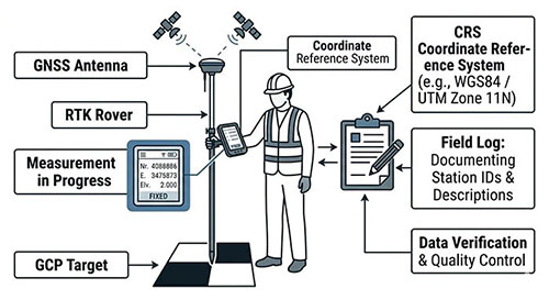
The rover uses network RTK corrections through NTRIP. The project coordinate system has been configured and checked against known control.
The crew moves through four locations.
| Location | Positioning status | Example reported horizontal precision | Field decision |
|---|---|---|---|
| Open area | Fixed | 0.012 m | Verify control, then proceed if within tolerance |
| Beside a building | Float | 0.256 m | Do not use for centimeter-level stakeout |
| Under dense trees | Single | 1.842 m | Suspend precision measurements |
| Back in open area | Fixed | 0.013 m | Recheck control before resuming critical work |
These values represent hypothetical controller estimates, not independently verified coordinate errors.
Location A: Open Area — Fixed
The rover tracks satellites with good sky visibility and receives timely corrections.
It reaches Fixed and reports a small estimated precision value.
The surveyor checks an independent control point and confirms that the coordinate differences satisfy the project's requirements.
The crew begins measuring.
The important point is that the decision is supported by both the solution status and a control check.
Location B: Beside the Building — Float
As the surveyor approaches a concrete-and-glass building, the available sky becomes restricted.
Some signals are blocked, while others may reach the antenna after reflection.
The receiver loses its fixed ambiguity solution and displays Float.
The reported precision increases.
The surveyor does not collect the foundation stakeout point as though nothing has changed.
Instead, the crew considers an alternative occupation, an appropriate offset technique or another instrument.
Location C: Under Dense Trees — Single
The rover enters an area with significant canopy obstruction.
Carrier-phase tracking becomes unreliable, and the receiver can no longer maintain an RTK solution.
It falls back to Single.
The receiver still provides an approximate location, but the result is not accepted for precision construction layout.
The surveyor records the obstruction and plans a different measurement method.
Location D: Back in Open Ground — Fixed Again
The crew returns to an open area.
Satellite tracking improves, the receiver receives suitable corrections, and the ambiguity solution becomes Fixed again.
However, the surveyor does not assume that every point observed during the earlier Float or Single periods has somehow become accurate.
Those observations retain the quality they had when collected.
For critical work, the crew verifies the restored solution using an independent control check before continuing.
What This Case Demonstrates
The status indicator describes the receiver's current positioning solution.
It does not retrospectively validate previous observations.
A return to Fixed is useful, but the surveyor must still consider the quality of the current observations and the accuracy requirements of the project.
RTK Fixed vs Float Accuracy: What Should You Compare?
The most common mistake is to treat Fixed and Float as two fixed accuracy ranges.
For example, a simplified chart may describe Fixed as centimeter-level and Float as decimeter-level.
Those descriptions can be useful as broad expectations, but they are not guaranteed limits.
A better comparison separates four questions.
1. Has the Ambiguity Resolution Succeeded?
Fixed indicates successful integer ambiguity resolution according to the receiver's processing and validation criteria.
Float indicates that the relevant ambiguities remain unresolved.
This is the primary technical distinction.
2. What Precision Does the Receiver Report?
Most survey controllers provide estimated horizontal and vertical precision indicators.
These estimates are useful for evaluating the current solution, but their definitions and calculation methods can differ between manufacturers.
They may not fully represent systematic errors or all sources of measurement uncertainty.
3. What Are the Observation Conditions?
A Fixed solution obtained in an open field with strong satellite geometry is not necessarily equivalent in reliability to one obtained beside a reflective structure.
Review the available quality information, including satellite tracking, correction age and environmental conditions.
4. Does the Result Match Independent Control?
This is a critical practical test.
If the measured coordinates do not agree with suitable known control within the project's acceptance criteria, a Fixed label does not justify accepting the result.
Why Does RTK Keep Switching Between Fixed and Float?
A receiver may alternate between Fixed and Float when the available carrier-phase observations change.
Several conditions can cause this behavior.
Satellite Obstructions
Buildings, trees, bridges and other structures can block satellite signals.
A reduction in usable observations may prevent the receiver from maintaining or re-establishing a reliable fixed solution.
Multipath
Signals reflected from nearby surfaces can distort measurements.
Multipath can make ambiguity resolution more difficult and, in some circumstances, contribute to unreliable positioning.
Cycle Slips
A cycle slip occurs when the continuity of a carrier-phase measurement is interrupted.
The receiver must detect and handle these interruptions, and the ambiguity-resolution process may need to recover.
Correction Problems
A rover requires suitable correction information for its RTK processing.
A poor radio connection, interrupted mobile-data service, excessive correction age or incompatible correction settings can prevent reliable RTK operation.
Baseline and Atmospheric Effects
For a local base-and-rover system, longer baselines can increase the challenge of modeling atmospheric differences between the receivers.
Performance depends on the equipment, correction method and prevailing conditions.
Receiver Configuration
Satellite tracking settings, correction formats, antenna configuration and other parameters may also affect positioning performance.
Repeated status changes should be investigated systematically rather than attributed automatically to receiver hardware.
Where Does DGPS or DGNSS Fit?
DGPS, more generally referred to as DGNSS, is another form of differential positioning.
It uses correction information to improve GNSS positioning, commonly through code-based measurements.
Traditional code-based DGNSS should not be confused with carrier-phase RTK Float or RTK Fixed.
DGNSS is not a positioning stage that comes after Fixed.
It is a different correction approach, and the labels shown by individual receivers may vary.
Depending on the correction service and equipment, DGNSS may provide sub-meter or meter-level performance, but no single accuracy range applies universally.
For centimeter-level engineering tasks, surveyors generally evaluate an appropriate RTK or other high-precision surveying workflow rather than assuming that any differential correction status is sufficient.
How to Know Whether an RTK Position Is Accurate Enough
The correct acceptance criteria depend on the job.
A topographic survey, a construction stakeout operation and a deformation-monitoring project do not necessarily have the same accuracy requirements.
A reliable field procedure should address the following points.
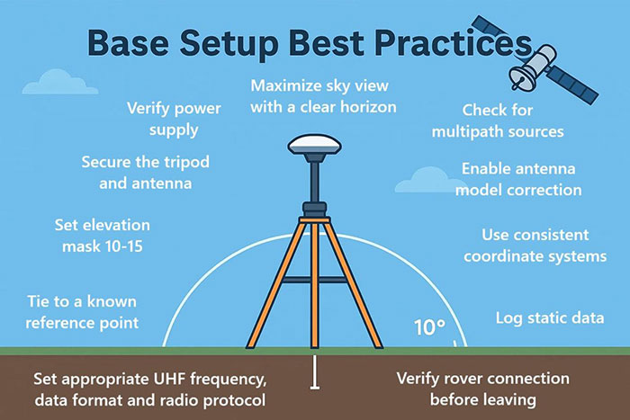
Confirm the Reference Setup
Check the base station coordinates or network correction reference, the project coordinate system and any site transformation.
For a local base-and-rover workflow, the base reference position is particularly important.
See our GNSS RTK base and rover setup guide for an explanation of the correction workflow.
Verify Antenna Height and Vertical Settings
Confirm the physical pole height, antenna reference method and vertical datum or geoid configuration.
A Fixed solution cannot compensate for an incorrect antenna-height entry.
Check Known Control
Measure suitable independent control points and compare the observed differences with the project requirements.
For critical work, use the number and distribution of control checks appropriate to the survey specification.
Review Solution Quality
Examine the positioning status together with available precision estimates, satellite tracking, correction age and observation conditions.
Do not use a single screen indicator as the sole acceptance test.
Repeat Measurements Where Necessary
Independent occupations, suitable time separation and alternative measurement methods can provide additional confidence.
Repeated readings taken under the same poor conditions may share the same bias, so repetition alone is not always enough.
Preserve Quality Information
Store the relevant observation metadata where the workflow allows.
Positioning status, estimated precision, correction information and field notes can be valuable when reviewing questionable points later.
When Should You Use a Total Station Instead?
GNSS RTK is highly productive in suitable outdoor conditions.
However, some environments make satellite positioning difficult.
Examples include dense urban corridors, areas beneath substantial tree cover, underground structures and locations immediately beside reflective buildings.
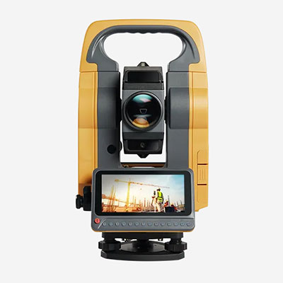
When reliable RTK observations cannot be established, a total station may offer a more appropriate measurement method, provided that its own control, setup and line-of-sight requirements can be satisfied.
For a comparison of the two technologies, read GNSS RTK vs Total Station: Which Should You Choose for Surveying?.
What Matters When Choosing a GNSS RTK Receiver?
A receiver's ability to obtain Fixed is important, but it is not the only factor that matters in professional surveying.
Consider how the complete system performs in the environments where it will be used.
Relevant factors include satellite tracking capability, correction compatibility, communication options, field software, quality indicators and support for the required coordinate-system workflow.
For construction work, the ability to verify control and manage survey settings correctly is just as important as obtaining a Fixed status quickly.
RTKSurvey.com supplies GNSS RTK receivers for surveying, engineering and construction applications.
Equipment selection should be based on the actual working environment, correction infrastructure and required survey accuracy rather than a single advertised specification.
Frequently Asked Questions
Is RTK Fixed Always More Accurate Than Float?
A correctly resolved Fixed solution generally supports more precise relative positioning than a Float solution under comparable conditions. However, an incorrect fixed solution or a reference-configuration error can still produce inaccurate coordinates.
Can RTK Float Be Used for Surveying?
That depends on the task, the demonstrated accuracy and the applicable survey requirements. Float should not automatically be accepted for centimeter-level control or stakeout simply because correction data is being received.
Why Does My GNSS Receiver Show Single Even with Satellites Available?
Satellite tracking alone does not establish an RTK solution. The receiver may lack suitable correction data, sufficient usable carrier-phase observations or a valid ambiguity solution.
How Long Does It Take to Get RTK Fixed?
There is no universal time. The result depends on satellite availability, signal quality, correction delivery, baseline conditions and receiver processing. Some setups obtain Fixed quickly in open sky, while difficult conditions may delay or prevent it.
Does RTK Fixed Mean the Position Is Accurate to 1 cm?
No. A Fixed label does not guarantee a specific absolute accuracy. The receiver's specifications, reference configuration, observation conditions and independent control checks must all be considered.
What Happens to Points Measured During Float After the Rover Returns to Fixed?
Previously stored observations do not automatically improve when the current solution changes to Fixed. Their suitability must be evaluated using the quality and verification information available at the time of measurement.
What Is the Difference Between RTK and DGNSS?
RTK uses carrier-phase observations and ambiguity resolution for high-precision relative positioning. Traditional DGNSS commonly applies code-based differential corrections. Their achievable performance and intended applications differ.
Final Thoughts
RTK Fixed, Float and Single are useful indicators of how a GNSS receiver is determining its position.
Single provides a standalone position without an RTK fixed solution. Float uses carrier-phase processing with unresolved ambiguities. Fixed indicates that the relevant integer ambiguities have been resolved.
But a positioning label is not a complete accuracy assessment.
Reliable surveying requires suitable observations, correct reference information, properly configured equipment and verification against independent control.
The practical question is not simply “Does the receiver show Fixed?”
It is “Can this measured coordinate be trusted for the accuracy required by the job?”