Welcome to RTKSurvey.com

GNSS RTK vs Static GNSS Surveying: Key Differences and Applications
GNSS RTK and static GNSS surveying both use satellite observations to determine accurate positions, but they are designed for different field workflows.
RTK provides corrected coordinates in real time, making it useful for collecting many points across a construction site. Static GNSS requires a receiver to remain stationary while observations are recorded for later processing, making it particularly valuable for establishing survey control.
The choice is not simply about which method is more accurate. Surveyors also need to consider observation time, reference coordinates, correction availability and the purpose of the measurements.
1. What Is GNSS RTK Surveying?
Real-Time Kinematic (RTK) surveying uses carrier-phase GNSS observations and correction information to calculate precise rover positions while the surveyor is working.
Corrections can come from a local base station or a network service such as NTRIP.
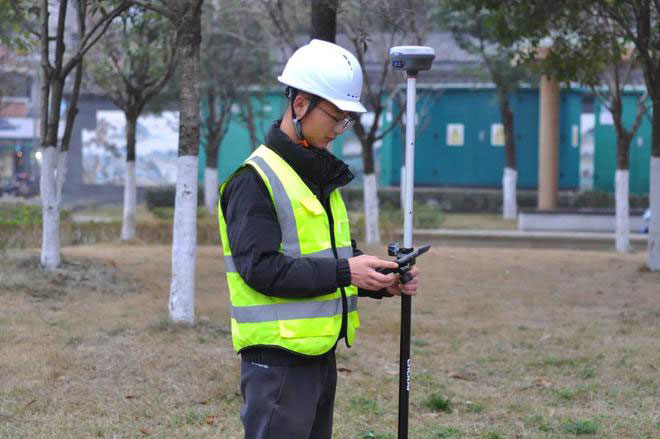
Once the rover obtains a reliable RTK Fixed solution, the operator can measure points, perform stakeout and check coordinates without waiting for office processing.
For example, a construction surveyor may use RTK to measure road edges, utility locations and ground elevations across a project site.
The main advantage is productivity: many points can be collected within a relatively short period.
However, RTK depends on suitable satellite observations, reliable corrections and correct reference coordinates.
A Fixed solution alone does not guarantee that the coordinates are correct. For more detail, read our RTK Fixed but Wrong Coordinates troubleshooting guide.
2. What Is Static GNSS Surveying?
Static GNSS surveying involves setting up a receiver over a fixed survey point and collecting satellite observations without moving the antenna during the session.
The recorded data are subsequently processed using observations from one or more reference stations.
Unlike RTK, the final survey coordinates are not normally calculated through a live correction link in the field.
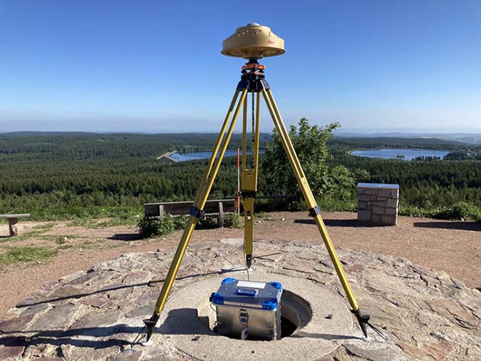
Static GNSS is commonly used to establish or strengthen geodetic control networks, determine coordinates for permanent survey monuments and connect projects to an established reference framework.
How Long Does a Static GNSS Survey Take?
Observation time depends on baseline length, satellite geometry, site conditions, required accuracy and the processing method.
Some rapid-static procedures use relatively short sessions, while conventional static control surveys may require hours of observation or multiple independent sessions.
There is no universal observation time suitable for every project.
For high-accuracy control work, the survey plan and applicable surveying standards should determine the session duration.
3. GNSS RTK vs Static GNSS: Main Differences
| Feature | GNSS RTK | Static GNSS |
|---|---|---|
| Positioning result | Available in real time | Usually obtained after processing |
| Receiver movement | Rover moves between points | Antenna remains fixed during each observation |
| Observation time | Usually seconds to minutes per point | Minutes to hours, depending on method |
| Correction workflow | Live base or network corrections | Recorded observations processed afterward |
| Internet or radio | Often required for live corrections | Not required during field observation |
| Common applications | Topographic surveys, construction layout, stakeout | Control networks, reference monuments, geodetic surveys |
| Main advantage | Fast field productivity | Strong control-survey workflow with longer observations and redundancy |
| Main limitation | Correction connectivity and reference errors | Longer occupation and processing time |
Both methods can produce high-quality coordinates when properly planned and executed.
The most important difference is how they balance field productivity, observation duration and quality control.
4. Which Method Is More Accurate?
Static GNSS is often preferred for demanding control surveys because longer observations and post-processing provide opportunities to evaluate data quality and strengthen the solution.
RTK is designed for rapid positioning and can also achieve centimeter-level accuracy under suitable conditions.
However, actual accuracy depends on the equipment, satellite geometry, baseline length, atmospheric conditions, multipath, coordinate reference framework and measurement procedures.
A poorly executed static survey can produce unreliable results, just as an RTK rover with an incorrect base coordinate can produce consistently shifted positions.
Accuracy Is Not Just a Receiver Specification
When comparing GNSS methods, distinguish between:
Precision: How closely repeated measurements agree
Accuracy: How close the result is to the correct position in the intended reference framework
Repeatability: Whether independent observations produce consistent results
Control quality: Whether the reference stations and coordinates are trustworthy
A receiver displaying a small estimated error does not remove the need for independent checks.
5. When Should You Use RTK?
RTK is particularly useful when a project requires a large number of points or immediate field decisions.
Construction Layout
A surveyor can stake out foundations, road alignments and utility positions while checking coordinates in real time.
Topographic Surveys
RTK allows teams to collect ground features and elevation points efficiently where satellite visibility is adequate.
Site Verification
Contractors can compare measured positions with design coordinates without waiting for post-processing.
RTK is usually a strong choice when the project already has reliable control and the field crew needs speed.
For a detailed workflow, see our GNSS RTK Base and Rover Setup guide.
6. When Is Static GNSS the Better Choice?
Static GNSS is particularly valuable when establishing a reliable coordinate foundation for later surveying work.
Establishing Survey Control Points
A project may need permanent reference monuments before construction begins.
Static observations, appropriate processing and network adjustment can help establish these points within the required reference framework.
Long-Baseline Control Surveys
For some projects, the required control network extends over distances where conventional single-base RTK is less suitable.
Static GNSS may offer a better workflow for processing and evaluating the observations.
High-Accuracy Engineering Projects
Infrastructure and monitoring projects may require documented control quality, repeated observations and independent checks.
Static GNSS can support these requirements when used according to the relevant specifications.
7. Field Example: Road Construction Project
Consider a hypothetical road construction project extending across several kilometers.
Before the construction crew begins daily layout work, the surveying team needs reliable reference points along the route.
The team first establishes several control monuments and observes them using static GNSS.
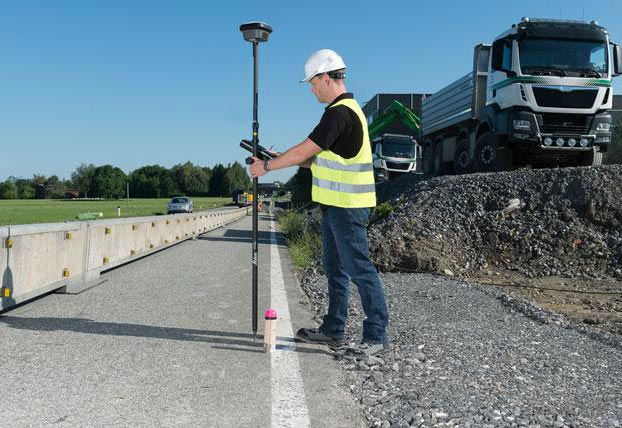
After processing and checking the control network, the surveyors use those verified points to support RTK measurements.
During construction, the RTK rover is used to stake out road features, measure ground points and verify positions.
In this workflow, static GNSS and RTK are not competing methods.
Static GNSS helps establish the control framework, while RTK helps the field crew work efficiently within it.
The precise workflow should follow the project's survey specifications and coordinate requirements.
8. Can the Same GNSS Receiver Perform RTK and Static Surveys?
Many professional multi-frequency GNSS receivers support both RTK positioning and raw observation logging for static processing.
However, support varies by model, firmware and software configuration.
Before purchasing, check whether the receiver provides:
RTK rover and base functionality
Raw GNSS observation logging
RINEX export or supported conversion tools
Suitable sampling intervals and observation storage
Compatibility with the intended post-processing software
Required antenna calibration information
Do not assume that every RTK receiver includes unrestricted static data logging or all necessary software licenses.
You can explore available models in our GNSS Receivers category.
9. What About PPK and Rapid Static?
These terms are related, but they should not be treated as interchangeable.
PPK (Post-Processed Kinematic) typically involves recording GNSS observations while a rover moves between or occupies points, then calculating corrected positions after fieldwork.
Rapid static uses stationary observations with a shorter occupation period than many conventional static surveys, subject to baseline, equipment and processing requirements.
Conventional static GNSS generally uses longer stationary observations, often with additional redundancy for control work.
To understand the difference between real-time and post-processed kinematic positioning, read our GNSS RTK vs PPK comparison.
10. How to Choose the Right Method
Before deciding between RTK and static GNSS, ask four practical questions.
Do you need coordinates immediately?
If field crews must perform stakeout or make decisions while surveying, RTK is usually more convenient.
Are you establishing permanent control?
If the work requires a documented reference network with high confidence, static GNSS may be more appropriate.
Are live corrections available?
RTK requires a suitable correction source and communication link. Static GNSS can collect observations without receiving corrections during the session.
Does the project specify a particular survey method?
Contract requirements, local standards and required uncertainty may determine which methods are acceptable.
In many engineering projects, the best solution is to use both methods for different stages of the work.
Frequently Asked Questions
Is Static GNSS Always More Accurate Than RTK?
No. Static GNSS is often preferred for high-accuracy control surveys, but actual results depend on observation quality, processing, reference data and survey procedures. RTK can also deliver centimeter-level positioning under suitable conditions.
Does Static GNSS Need a Base Station?
Static GNSS processing requires appropriate reference observations. These may come from a locally operated receiver or suitable continuously operating reference stations, depending on the processing workflow.
Can I Use RTK to Establish Control Points?
RTK may be suitable for certain control tasks when the required standards permit it and adequate independent checks are performed. Higher-order control projects may require static observations and network adjustment.
Does Static GNSS Require Internet Access?
Not necessarily during field observation. Internet access may be needed later to download reference data or use online processing services.
Which Method Is Better for Construction Surveying?
RTK is often more efficient for daily layout and topographic measurements. Static GNSS is useful for establishing the reliable control framework that supports those activities.
Final Thoughts
GNSS RTK and static GNSS surveying solve different problems.
RTK provides fast, corrected field positions for construction layout, topographic measurements and everyday survey operations.
Static GNSS provides a workflow for collecting longer observations, processing reference relationships and establishing reliable survey control.
For many projects, using static GNSS to establish control and RTK for daily fieldwork is more effective than relying exclusively on either method.
RTKSurvey.com supplies multi-brand GNSS receivers and surveying equipment for international surveying companies, engineering contractors and equipment distributors.
If you are comparing GNSS receivers for RTK, static or combined workflows, contact RTKSurvey.com with your intended application, required accuracy and preferred brands to discuss suitable equipment.